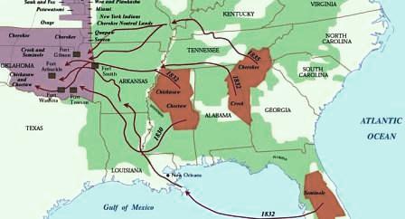
The Trail of Tears Map
The Trail of Tears Map shows the distance of the routes taken from the tribal homelands of the tribes (in brown) to the Indian reservation in Oklahoma.
Trail of Tears Map
The Trail of Tears was the name used to describe to the 1000 mile route that the Five Civilised Tribes were forced to travel, from their homelands in the Southeastern United States to reservations in Oklahoma. The term 'Trail of Tears' was first used by the Choctaw tribe in 1832. The Trail of Tears Map provides a bird's eye view of the location of the lands covered on their perilous journey.
Where is the Trail of Tears?
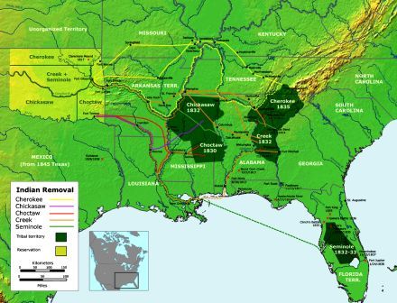 | 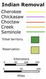 |
| Trail of Tears Map | Trail of Tears Map Key |
Trail of Tears Map - Where is the Trail of Tears?
The Trail of Tears was the name the Cherokee gave to the route they were forced to travel as a result of the Indian Removal Act. The Trail of Tears route ran from their land in the East to the reservation land west of the Mississippi - it was a 1000 mile march. Their tragic journey and route to the Indian Territory along the Trail of Tears, shown on the above map, was a desperate affair under severe conditions. Men, women, children and babies were forced to make the 1000 mile march as indicated on the Trail of Tears Map. There were few horses and many Cherokee were not prepared for the journey and the terrible cold they would experience on the route of the Trail of Tears. The above Trail of Tears Map shows the location of the lands and the route they followed and answers the question "Where is the Trail of Tears?".
Trail of Tears Map - The Tribes that walked the Trail of Tears
The Trail of Tears Map and the key to the map provides details of the routes taken by the Five Civilised Tribes from their homelands in the Deep South to Oklahoma. The Five Civilised Tribes consisted of the Cherokee Tribe, the Choctaw tribe, the Creek tribe, the Seminole tribe and the Chickasaw tribe. The Homelands and route of the march for each of these tribes is shown on the key to the Trail of Tears Map. For additional fast information refer to the Trail of Tears Facts.
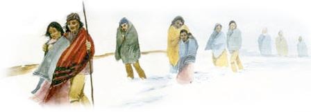
Picture of the Trail of Tears
Trail of Tears Map - The Story of the Trail of Tears
Forced from their traditional homelands men, women and children were forced to walk over 1000 miles facing the most terrible trials. The tragedy of the Trail of Tears was made even worse by the hazards that the people encountered on the journey of misery, sickness, and death. The people suffered from exposure in extremely cold weather conditions, inadequate clothing, malnutrition and starvation and fatal diseases. To walk the Trail of Tears it took 6 long months. The area covered was immense as can be seen from the Trail of Tears Map. One person out of every four died on the forced march across the route which became known as the Trail of Tears. For additional facts and information click the
History of the Trail of Tears
Trail of Tears
- Interesting Facts and information and a Trail of Tears Map
- Trail of Tears Map
- Facts and interesting info
- Lands & Tribal territories
- Trail of Tears Map
- Cherokee Trail of Tears Map
Pictures and Videos of Native American Indians
Trail of Tears. Discover the vast selection of pictures and videos of Native Indians. The pictures show the clothing, weapons and decorations that can be used as a really useful educational resource for kids and children of all ages. Our series of videos enable fast access to the images, pics, paintings and pictures together with information and many facts. We hope that this article on Trail of Tears will assist in your studies or homework and that you will enjoy watching the videos featuring many pictures of the Native Indians.